Culcheth Walk
For people who may not be familiar with the village this is a little walk through some of the history of Culcheth. It's an easy walk, about three miles, mostly level, along village roads and paths through a linear park and fields.
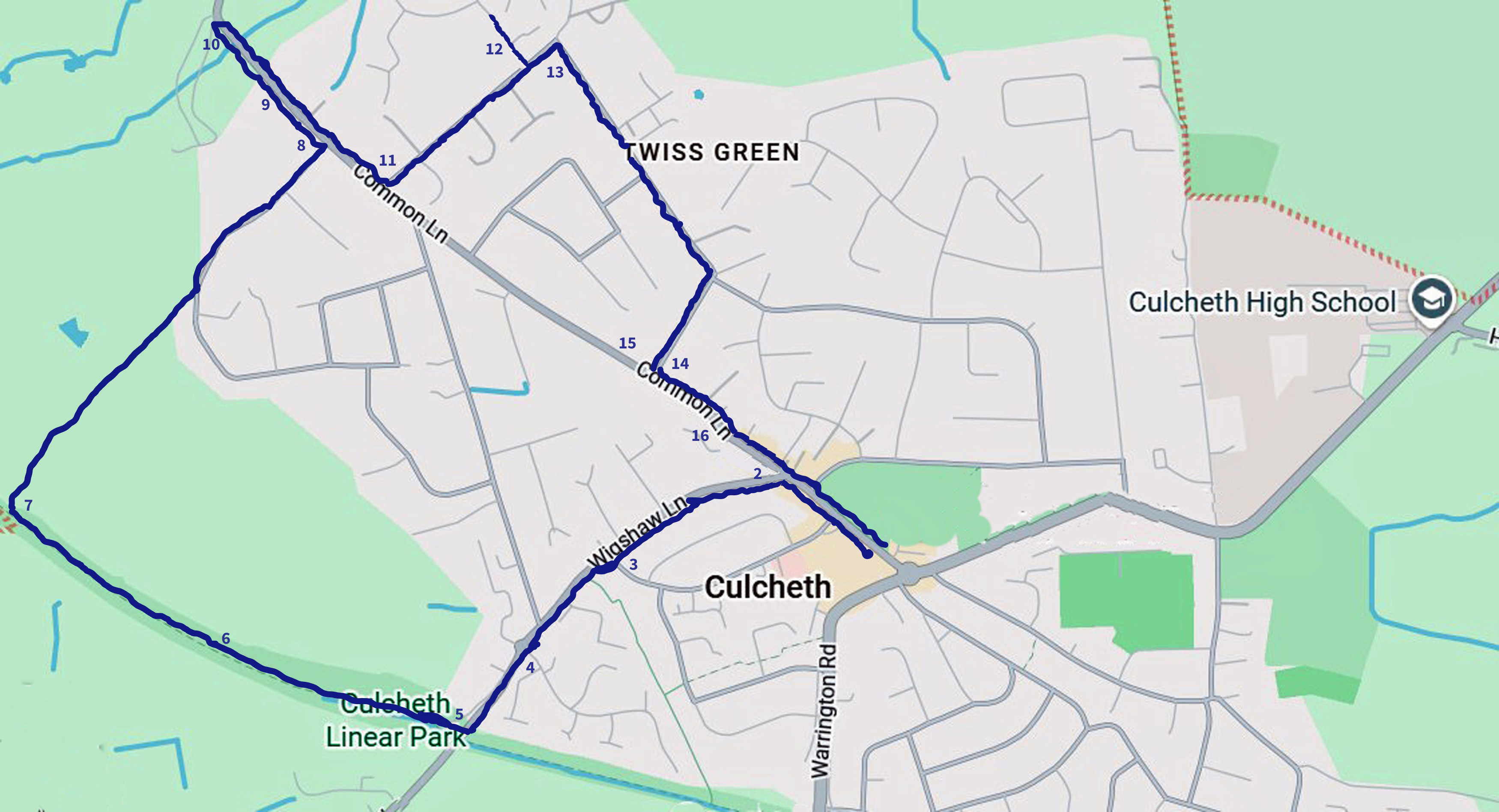
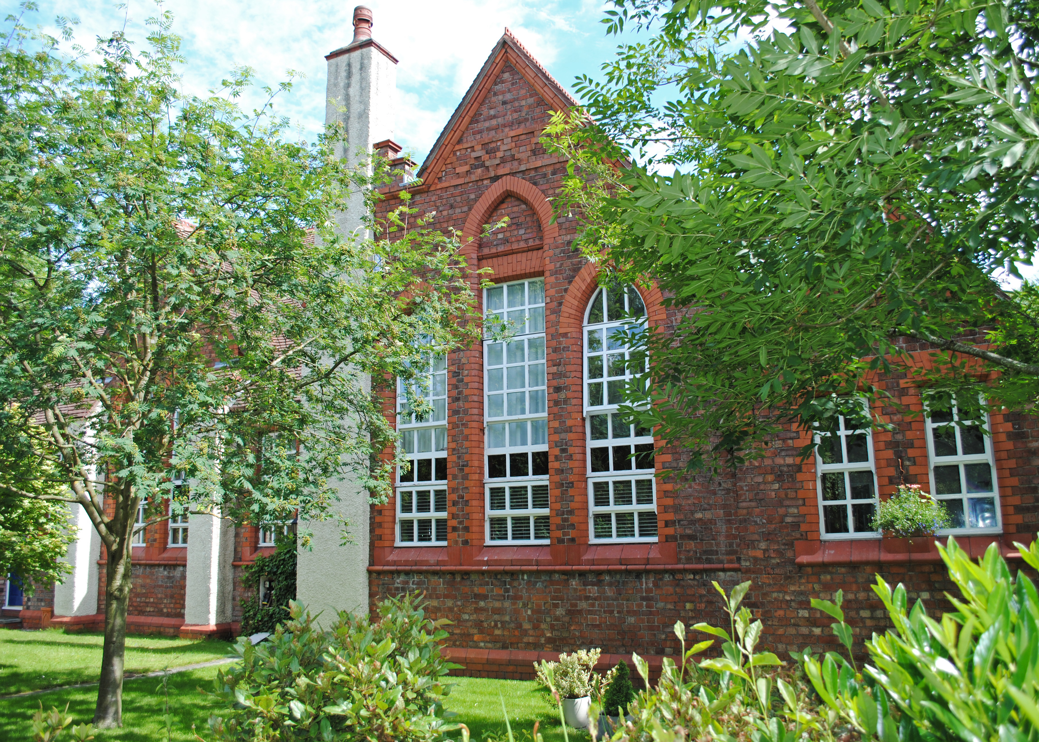
Start on the village green (1) near the children's playground, facing Sainsbury's. The old red brick building to the left of Sainsbury's is the old Newchurch School dating back to 1821, which is now a community hall used for various activities. Originally it was just a Sunday school run by the church to teach children and adults to read the bible. After 1870 it would have offered a broader elementary education for children aged between 5 and 13, but it was not compulsory and not free unless you were very poor.

You may notice that Sainsbury's is located in a building called Sundial House. The name derives from a large 17th Century house, with a large sundial on the front, which used to be situated in the area behind the new building. It was used as a Workhouse for a time and later became a private residence.
Walk up Wigshaw Lane between the Cherry Tree pub & Waterfields (2), which used to be the village post office. As you walk up the left hand pavement of Wigshaw Lane you will pass several old cottages and then cross over Jackson Avenue. Just after this junction (3) you will see an old farmhouse on your left - this is Brookhouse, a listed building dating back to 1744. It originally had a stone slate roof but was later fitted with Welsh small slates.
Further up Wigshaw Lane you will see on your right the junction with Hob Hey Lane and then a mini-roundabout. Beyond the roundabout on your left you will see modern houses, Pendle Gardens (4). In the 1940s this area housed workers for the massive munitions factory at Risley. These workers, mostly women, had the dangerous job of filling shells and bombs with explosive for the second world war. After the war Risley became the headquarters for Britain's atomic energy programme, initially for building a nuclear weapon and later for building nuclear power stations. Until the 1990s the area of Pendle Gardens was occupied by the Safety & Reliability Directorate, mainly staffed by atomic energy research scientists and engineers.
As you approach the bridge beyond the mini roundabout take the road to the right of the bridge sloping down to Culcheth Linear Park. At the bottom you will find an open area that used to be Culcheth Station (5). A railway line here first opened to goods in 1879 but it was 1884 before a station was built with two platforms and a booking office. The line was closed in 1968 and the station demolished in 1978 leading to the development of this pleasant Culcheth Linear Park.
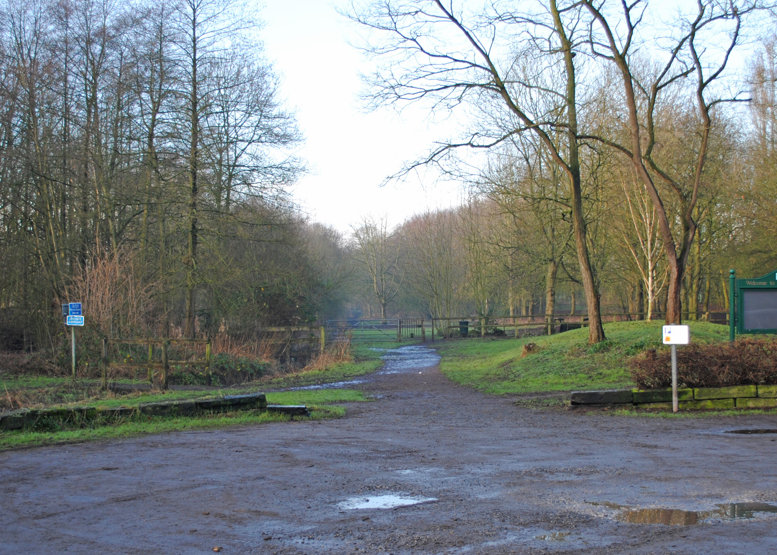
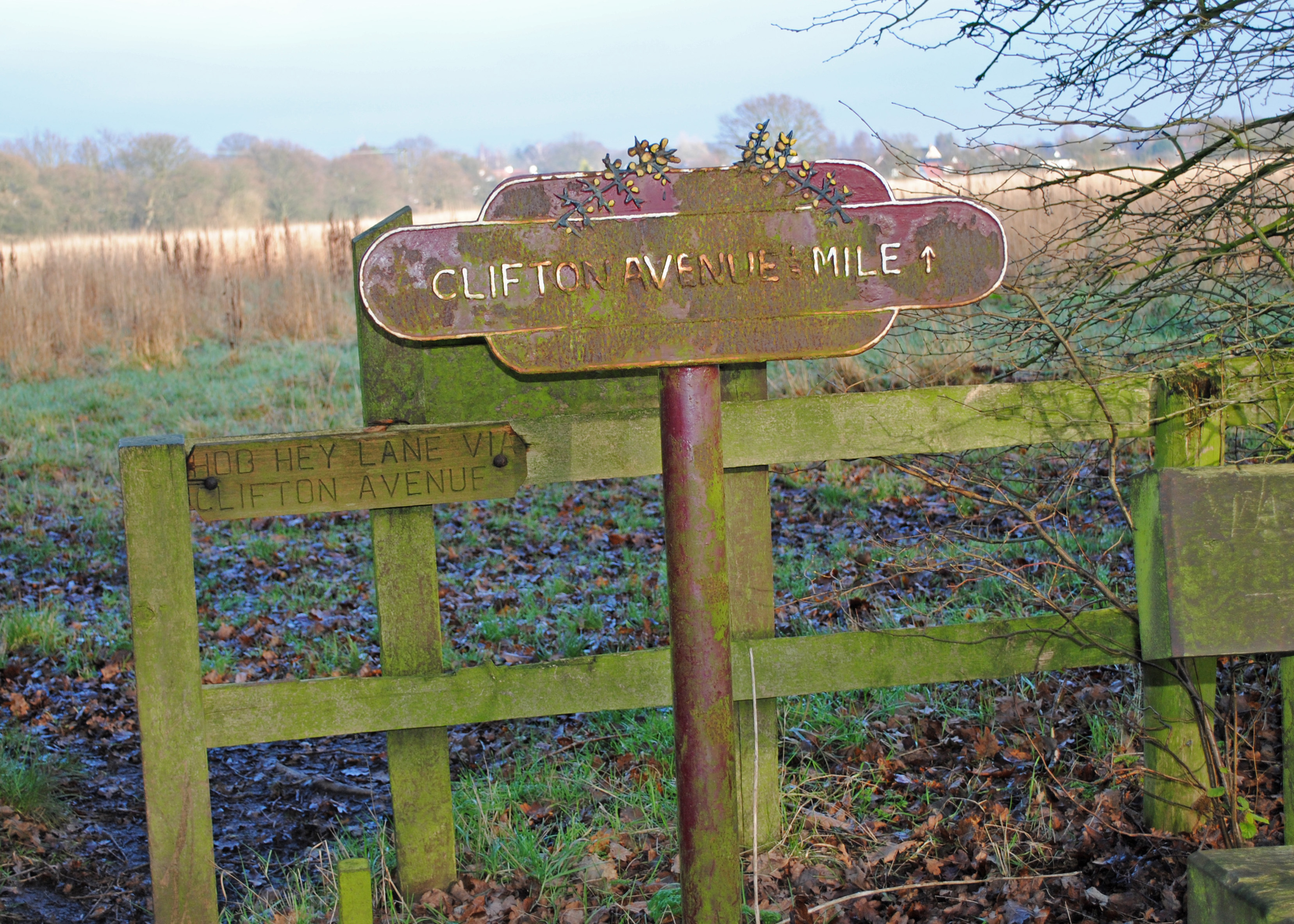
Continue in the direction away from the bridge. You will be following the track of the old railway but it is best to keep to the upper path on the right that runs alongside fields. Continue past the exit on your right marked to Clifton Ave (6). There is a bench here if you want to sit for a few minutes to spot any birds, insects or other small animals in the park.
At the next bridge go to the right to pass by it. Take the path about 20 metres beyond the bridge that heads about 90 degrees away from the linear park (7). This crosses a field and then passes by the golf course to exit onto Broseley Avenue. Turn left and walk down the road past some large houses. As you approach the T junction (8) if you look to your left through the trees you will see a large white house. This is Leigh Golf Club but it was once Kenyon Hall, owned by a wealthy cotton manufacturer from Manchester called Sir Jabez Johnson Ferguson. In 1894 it became Kenyon Hall College a private boarding school and the 1901 census records that it had 52 boys and 17 girls aged nine to seventeen. It ceased to operate as a school in the early 1920s when Leigh Golf Club took over.
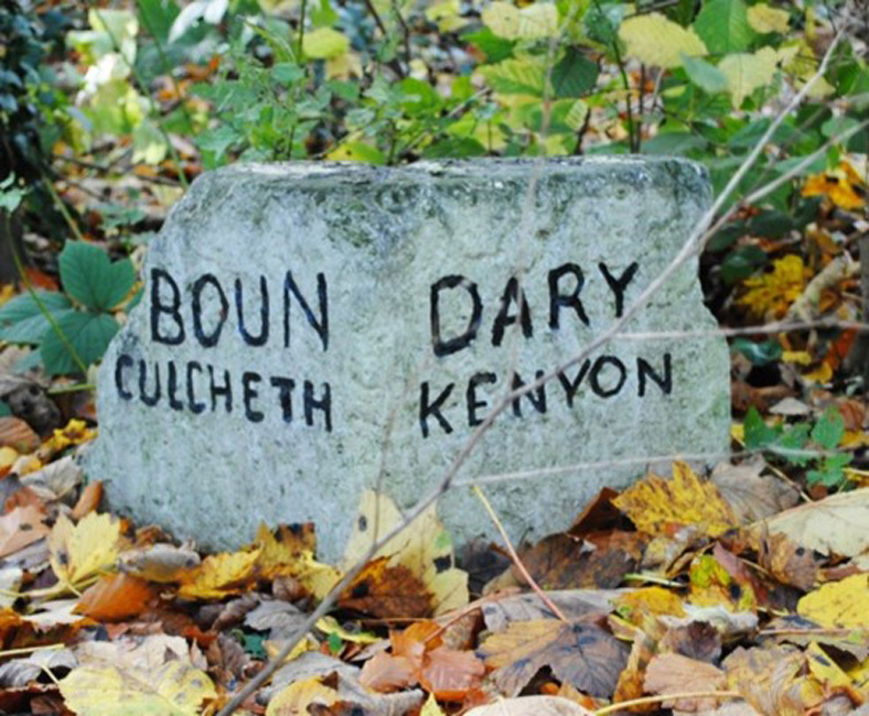
Our route is going turn right at the junction but you may want to turn left first for a little detour to get a better look at Kenyon Hall and the gatehouse at the entrance, which are both listed buildings. If you do, you will also pass another 'listed building' at the roadside: a small stone (9) marking the boundary between Culcheth and Kenyon. You will also notice old white cottages near to the golf club entrance (10) which were originally built for employees of Kenyon Hall. Later, one became the school laundry and the other used to be Kenyon post office.
We will now walk back towards Culcheth down Broseley Lane and Common Lane. As you approach a fork in the road you will see the old Methodist Church on the junction, which is now a private house. Before that junction turn left into Twiss Green Lane (11). After about 200 metres turn left into Eddisford Drive (12). The large buildings and houses that you see near to this road and around Stonyhurst Crescent were originally built in 1903 for poor and orphan children of Salford funded by the Salford Board of Guardians. This was a 'model village' providing supervised housing, school, baths, workshops, recreation ground and farm land. The children would attend school until age 14 and then receive practical training in workshops which included Shoemaking, Plumbing, Baking, Painting, Joinery, Gardening and farm work. The homes were almost self-sufficient. In 1911 it was catering for over 300 inmates and had a staff of 37. The original cost to the Salford Board of Guardians was £4,500 for 47 acres of land, £61,211 for the buildings and £2,500 for furnishings. Imagine what it is worth now.
Retrace your steps back down Eddisford Drive and turn left to continue down Twiss Green Lane (13). Follow the road right and after about 400 metres follow Twiss Green Lane round a sharp right turn. When you reach the T-junction with Common Lane (14) you will notice a white bungalow on your left at an angle to the road. This used to be the gatehouse on a path to Culcheth Hall. Culcheth Hall used to be the residence of the 'lord of the manor' Captain Thomas Ellames Withington but it no longer exists. If you want to look along Common Lane, just beyond the house to the right of this junction (15), you will find a small area of open green which used to be used for maypole dancing.
Turn left down Common Lane. At the bottom of the short hill you will notice Daisy Bank Mill Close on the right (16). There used to be a cotton mill called Daisy Bank Mill on this site and the terrace of old houses alongside the road were built for the workers. Continue straight on back to your starting point.